

Advertisement.
NWT Highway 3 reopened between Fort Providence and the Highway 9 intersection after an hours-long closure, while there’s a warning that a fire could reach Highway 1 in the days ahead.
We’re providing updates on the territory’s wildfires on this live page. Scroll down for the latest news.
Highway 3 was closed at 10am due to an incident. The precise reason is not yet clear. A lineup of traffic built outside Fort Providence until the highway eventually reopened just after 6pm.
The NWT government said early-morning closures will be enforced in the coming days because of concerns about morning fog and visibility.
Advertisement.
Advertisement.
Fort Providence and Whatì remain under evacuation orders. Jean Marie River remains on evacuation alert. Conditions on Thursday were not expected to drive wildfires toward any of those communities.
However, fire FS014 northwest of Jean Marie River is also a potential threat to Highway 1 leading to and from Fort Simpson, and the ferry landing on the eastern bank of the Liard River.
“The fire may reach Highway 1 and the Liard River within the coming days under east to southeast winds expected today, tomorrow, and Sunday – which would be expected to push the fire to the west,” NWT Fire stated on Thursday afternoon.
At the moment, the fire is about five kilometres from the road, the wildfire agency added.
Advertisement.
Advertisement.
Earlier, the Mayor of Fort Providence said he was confident that this week’s work to protect the hamlet from a wildfire is paying off.
Danny Beaulieu said in a message to residents late on Wednesday that “everything went well” fighting wildfire SS014 over the past day.
“The town is safe, 95-percent sure,” Beaulieu wrote.
Fort Providence residents have been out of their homes since Sunday, when the fire came within a kilometre of the community. Whatì evacuees have now been away from their community for almost a week.
The Behchokǫ̀ evacuation centre has closed and any evacuees using it have been relocated to Yellowknife.
Light showers over Whatì on Wednesday helped fire crews, while winds weren’t as strong as expected. However, NWT Fire stated: “It is not yet safe to return to the community as visibility is extremely poor and the fire is extremely close to Whati.”
Separately, the CBC reported a fire east of Yellowknife had burned through Vital Metals’ camp at the Nechalacho mine site. Nobody was hurt.
The NWT’s premier and environment minister, meanwhile, have responded to criticism levelled at the territory by former MP (and Fort Providence evacuee) Michael McLeod at a Tuesday public meeting.
Advertisement.
Advertisement.
RJ Simpson and Jay Macdonald said the territory’s firefighters were doing everything safely in their power to protect communities.
On this page, we’ll bring you updates on the NWT’s wildfires throughout Thursday. To get in touch, email [email protected].
Live reporting by Ollie Williams
All times MT
18:32 – We will have a slightly more detailed report on Highway 3 once I get back from this dog walk (the dog is not impressed with all this mid-walk journalism).
In the meantime, that concludes live updates for today. More tomorrow. Take good care on those roads.
18:27 – Highway 3 has reopened but only till midnight. This is from the GNWT:
“Highway 3 is currently open and is expected to remain open until midnight tonight.
“From September 5-8, Highway 3 will be closed each night between Fort Providence and Highway 9 Junction starting at 12 am. The road will reopen each morning around 8 am if conditions allow.
Advertisement.
Advertisement.
“The decision to close this section was made with respect to public safety, as fog patches are expected to develop overnight and persist into the early morning hours over the next few days.”
While we don’t have confirmation of the cause of today’s closure, our understanding is a collision occurred in a mix of fog and smoke this morning.
18:02 – The Department of Infrastructure just said it is still gathering information about the Highway 3 closure and won’t have any comment on what caused it until tomorrow.
As far as I am aware, the highway remains closed.
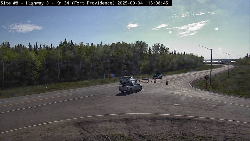
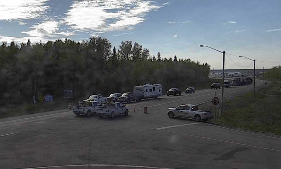
17:10 – People keep calling about Highway 3. The only official information I have is that it remains closed. The Drive NWT camera shows a long old lineup in Fort Providence again.
I have asked the GNWT and RCMP to tell us what happened earlier today. I’m awaiting responses on both fronts. I do have one account sent in to us that describes a collision involving two semi trucks in zero-visibility conditions this morning – I’m working on confirmation of that.
If you’re planning on driving the highway any time soon, keep following this page and hopefully we’ll get an update in the near future.
16:20 – Friday weather forecast time. According to NWT Fire, this is what you can expect tomorrow:
Advertisement.
Advertisement.
ZF048, Whatì: Hot, windy weather with low visibility due to smoke. Southerly winds will be 20-25 km/h, gusting up to 40 km/h.
FS014, Jean Marie River and Fort Simpson: Similar to today, with wind from the southeast of up to 10 km/h with 20 km/h gusts. That would push the fire away from Jean Marie River but NWT Fire says it would also mean “continued concern for westward growth under east-southeast winds” toward Highway 1 and the ferry landing.
SS014, Fort Providence: Hot, dry and windy with southeasterly winds gusting to 25-30 km/h and moderate relative humidity (in other words, the level of moisture in the air). “A challenging day, but the wind will be blowing the fire away from the community,” NWT Fire stated earlier.
16:15 – Still no firm update on Highway 3’s status or the cause of the disruption on that road today. It could well be fire-related but the use of the phrase “road incident” earlier implied something else.
In the meantime, we’ll take a look in a second at what conditions we should expect on Friday across the key areas where fires are causing concern.
15:16 – A further clue in the game of is-the-highway-open: the webcam at Fort Providence shows almost the entire lineup of vehicles has disappeared. Either they’ve all gone around the corner to mess with me or Highway 3 is indeed allowing at least some traffic through.
However, it looks from the webcam image like the road is still blocked, so it may be that traffic is being escorted through in waves.
15:00 – Tony Brushett from The Salvation Army in Yellowknife has been in touch:
Advertisement.
Advertisement.
“One of the things we are really having great difficulty getting for the folks who are at the evacuation centre is towels,” Tony writes.
“I’ve bought every towel I can find in Yellowknife and I’ve gotten every towel I can get from our thrift store but we’re now out of them again.”
If you have spare towels at home, Tony would be grateful if you could bring them to The Salvation Army Thrift Store at 4926 44 Street (not the evacuation centre, they’ll handle that part).
14:53 – I have an email in from one person reporting movement for the traffic stuck on either side of the Highway 3 incident (thank you for getting in touch!). One driver, at least, reports that they are moving again. That’s very much from an unofficial source and there’s no confirmation from the GNWT via Facebook or Drive NWT yet.
14:34 – We have a Fort Providence update too on fire SS014.
The main takeaway is that the ignition line firefighters put in around the north of the community is holding well, but there are “still safety concerns” until more work is completed.
“Friday’s conditions are expected to be hot, dry and windy, with southeasterly winds gusting 25-30 km/h,” NWT Fire states. “A challenging day, but the wind will be blowing the fire away from the community.”
In other news, in a bid to disrupt things, I have occupied a sofa at work that I never normally sit in. It turns out this has been the comfiest sofa in the office all along and nobody told me.
Advertisement.
Advertisement.
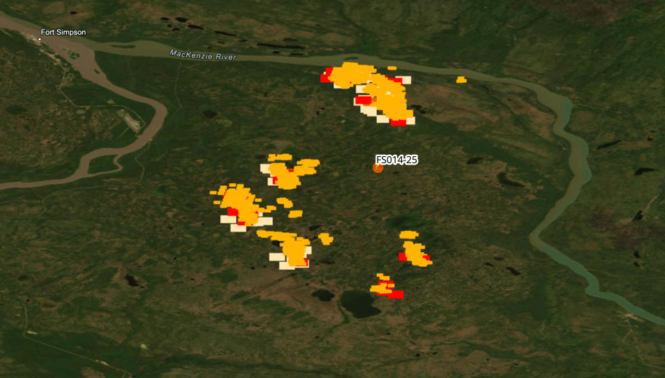
14:27 – The latest satellite hotspot pass took place at about 12:30pm. Not a lot happening around Whatì and Fort Providence (hurrah).
The map between Fort Simpson and Jean Marie River suggests fire FS014 is currently noodling around a bit. The red spots below are the ones detected at 12:30, everything else is from earlier.
14:10 – No wildfire updates of note in the past few hours. NWT Fire just issued an FS014 update that largely reiterates information Mike Westwick provided on the air just before 10am (see the 9:58am update).
There is a little more guidance on the fire’s possible impact on Highway 1, as follows:
“The fire is not expected to grow closer to Jean Marie River today. It may grow closer tomorrow. The fire may reach Highway 1 and the Liard River within the coming days under east to southeast winds expected today, tomorrow, and Sunday – which would be expected to push the fire to the west,” NWT Fire’s update states.
14:04 – My colleague Emily Blake has been working to identify how children from Whatì and Fort Providence are accessing education while they are evacuees.
A news report earlier this week suggested some Yellowknife schools had accepted students from evacuated communities. While the YK1 school district told us it’s ready to help, it’s not clear how many student evacuee, if any, have actually resumed their studies at any Yellowknife schools.
YK1 told Emily the “main focus is on making sure that everyone is safe.”
Advertisement.
Advertisement.
Assistant superintendent Graham Arts said by email on Wednesday that YK1 had “extended our offer of assistance to the Tłı̨chǫ District Education Council, and they know we are ready to help once they have determined what their needs might be.”
In the South Slave, Michael Holmberg – a public affairs coordinator at the South Slave Divisional Education Council – provided a statement from SSDEC.
“At this time, we have not received any requests from the Fort Providence school authority or community for support,” that statement read. SSDEC oversees schools in Hay River, where many Fort Providence residents are staying.
“The South Slave Divisional Education Council is prepared and willing to assist in any capacity. If families choose to have their children attend school in Hay River or Fort Smith, they are welcome to register and will be supported like any other student.
“However, given the possibility of families returning home and the availability of other communities such as Yellowknife, we have not received any registrations from Fort Providence students as of today.”
13:55 – A lineup of vehicles is developing in Fort Providence with Highway 3 now closed for four hours and counting. Here’s the webcam:
If you happen to be in one of those vehicles, feel free to email me (if safe to do so) and let me know what you’re being told and how your journey had been going. Hopefully everyone is on the move soon.
13:16 – We’ll have a separate story on this shortly: United Way NWT has reactivated its Emergency Response Fund and is seeking donations to help emergency response and recovery in Whatì and Fort Providence.
Advertisement.
Advertisement.
This is the first time that fund has been active since the 2023 fires.
“Contributions will be redistributed directly to local organizations meeting the needs of evacuees and welcoming communities,” United Way NWT stated.
13:12 – Highway 3 is still closed. The Department of Infrastructure just told me it doesn’t have any more detail about the issue immediately available but will send an update when it does.
Drive NWT has now been updated to a shade of orange I hadn’t previously seen that notes the road is closed, “emergency access only.”
12:17 – The smoke in the Dehcho is bad enough that the chief public health officer has issued an advisory of “very high-risk readings,” urging people to check their local air quality reading and act accordingly.
11:47 – A little more now from Mike Westwick at NWT Fire on the conditions crews are facing today. We’ll start in Fort Providence with Whatì below (and check out the 9:58am entry for more on FS014 between Fort Simpson and Jean Marie River).
“We’re looking at continued favourable winds for Fort Providence,” said Westwick this morning. “We’re looking at winds coming from a similar direction, the south, southeast to southwest during the day. That would push the fire and the ignition line back on itself. It’s going to give us a good opportunity to get work done there, continue mopping up that ignition line, and continuing to move that fire into a much better place.”
In Whatì, Westwick said similar conditions are expected with a possible wind shift so that winds come from the north, which is good news for that fire.
Advertisement.
Advertisement.
“That ignition line has held well across the La Martre River,” Westwick said.
“Teams are going to continue mopping up that ignition line, working to eliminate threats for the community to make that place feel safe again.”
10:58 – From Łı́ı́dlı̨ı̨ Kų́ę́ First Nation Chief Kele Antoine:
“The smoke in our community today is very heavy and the air quality is unsafe. Breathing in this type of particulate is dangerous for your health. If you need to be outdoors, please wear a mask. We have masks available at the LKFN office and if you ask kindly, we can have some dropped off to you.
“While this smoke is uncomfortable, our community is not under threat from fire. We are grateful that the same winds bringing smoke into Fort Simpson are also pushing the fires away from Whatì, Fort Providence, and Jean Marie River.
“Let’s take care of ourselves by closing the windows, masking up, checking in on our Elders and immune compromised, and let’s also keep in our hearts the communities who are safer today because of these winds.”
10:50 – Drive NWT still says Highway 3 is open but the GNWT’s Facebook page still says it’s closed. Based on this webcam image from outside Fort Providence half an hour ago, I would suggest assuming it’s closed. I’ll keep an eye on the situation.

10:41 – The GNWT has just published an update about emergency allowances for evacuees who are on income assistance.
Advertisement.
Advertisement.
9:59 – Highway 3 is closed from the Highway 9 intersection all the way down to Highway 1 because of a road accident, the GNWT just stated on Facebook.
Check Drive NWT for the latest although I’ll note it’s currently showing Highway 3 as open when I look, so it may be that there’s some delay in updating that. I’d give it half an hour then look again, and watch the Department of Infrastructure Facebook page too.
9:58 – Here’s an assessment from NWT Fire’s Mike Westwick of fire FS014, burning between Fort Simpson and Jean Marie River, which looked lively via satellite hotspot detection overnight:
“Yesterday we had some really strong northwest winds that could have potentially made it grow significantly toward the south and the east. We didn’t see that play out. We were able to hold it at its closest point using air support, so we’re still looking at about 15 km to the northwest of Jean Marie River at its closest point,” Westwick told me just now.
“Today, we’ve got wind switch to the southeast that could push the fire to the west and the north. Folks will see fire activity from Fort Simpson in terms of smoke. We’re looking at a drier day, relatively light winds, 10 km/h gusting up to 15 km/h in the afternoon. We don’t expect it to impact the highway today but there is likely to be some growth toward it.
“Folks travelling on the highway should expect reduced visibility. As far as managing this fire, we’ll be working to attack it from the air whenever we can get crews on it, whenever visibility and safety allows for it, and continue to maintain those contingencies within Jean Marie River in terms of sprinkler setups.”
9:41 – Canada Post just sent an update for evacuees regarding their mail.
Fort Providence evacuees can now pick up mail at Hay River’s post office on Capital Crescent. Whatì evacuees’ mail is now at the Yellowknife main post office at 4902 50 Ave.
Advertisement.
Advertisement.
You need valid government-issued photo ID to get your mail, Canada Post said.
Meanwhile, residents and businesses in Fort Providence and Whatì can now register for free mail forwarding for up to a year. You have until October 3 to activate that if you want it. Go to a post office or head to Canada Post’s website for details.
9:22 – We’ll have an update from NWT Fire within the next half an hour on the general situation. In particular, I want to get details on FS014, which looks from satellite hotspot imagery like it had an active night. (I’m always conscious, though, that hotspot detection alone isn’t always 100-percent accurate and doesn’t always tell the whole story.)
Stand by for that.
9:10 – Coming up between 10am and 12pm on Cabin Radio, we’ll be hearing from Kevin Devoe, the Fort Providence RCMP officer who’s part of a team keeping the hamlet’s remaining dogs fed, among other duties. Sample quote from the interview: “Have I been emotionally upset? Yes. I mean, I’m a human being myself and just like everyone else, it really touches you. I’m just so glad we’re able to do this small bit to help people who are evacuated.”
Also exclusively revealed in the interview: does Kevin have a favourite Fort Providence dog? (The interview comes dangerously close to We Rate Dogs territory.)
Listen live to Cabin Radio here.
7:54 – Speaking of Drive NWT, no new road closures this morning. Highway 3 is open at the time of writing, Highway 9 and the Fort Prov access road are not.
Advertisement.
Advertisement.
Check before you travel, expect delays and so on.
7:50 – The air quality in Yellowknife now is great compared to recent days. The same cannot be said for the South Slave, where it looks like a smoky start, and there’s a gauge in Fort Simpson delivering a PurpleAir reading of 687, which is… bleak.
(The other gauges near it are in the 300s, which is not quite so apocalyptic but is still well into the “emergency” end of the scale.)
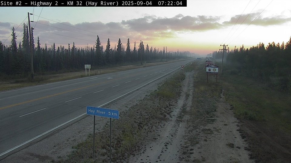
Here’s the scene looking toward Hay River this morning from the Drive NWT camera on Highway 2:
7:31 – Fort Providence Mayor Danny Beaulieu, senior administrator Susan Christie and ECC information officer Frank McKay are due to brief evacuees at the Hay River arena starting at 1pm today.
An update published by Christie last night stated: “The hamlet continues to work with Maca on re-entry planning so that when it is safe to return, there is a plan in place to bring everyone home in an organized manner.
“There is still no firm timeline for when we may be able to welcome you back, but we are doing everything we can to have you all back home soon.”
Advertisement.
Advertisement.
Department of Finance staff will be at the Hay River evacuation centre until the end of today to help with applications for financial relief, Christie stated.
“Payments are not expected to be made until next week,” she added.
7:14 – To be clear, much as I’m grumbling about the lack of fresh satellite imagery, it isn’t Sentinel’s job to go around hunting NWT wildfires. It’s used for lots of different things.
This is one of the reasons why Canada is building its own wildfire satellite array.
WildFireSat is supposed to launch by 2029. I’m told the public will have a lot of access to the information those satellites send back, and that system will be dedicated to Canadian wildfires, the idea being that wildfire managers can get information any time rather than waiting patiently for existing satellites to reach a useful position.
7:10 – The latest Sentinel-2 satellite pass managed to expertly miss every wildfire of note in the NWT, so there’s not much to examine on that front.
The Sentinel satellites don’t follow exactly the same path each day, so the area captured changes daily. Wednesday’s passes were over Great Slave Lake and the Mackenzie Mountains but not the region in between.
6:40 – Today’s forecast suggests a dry, calm day is ahead for much of the area we’re worried about. Here’s a snapshot of the expected wind conditions at 2pm:
Advertisement.
Advertisement.
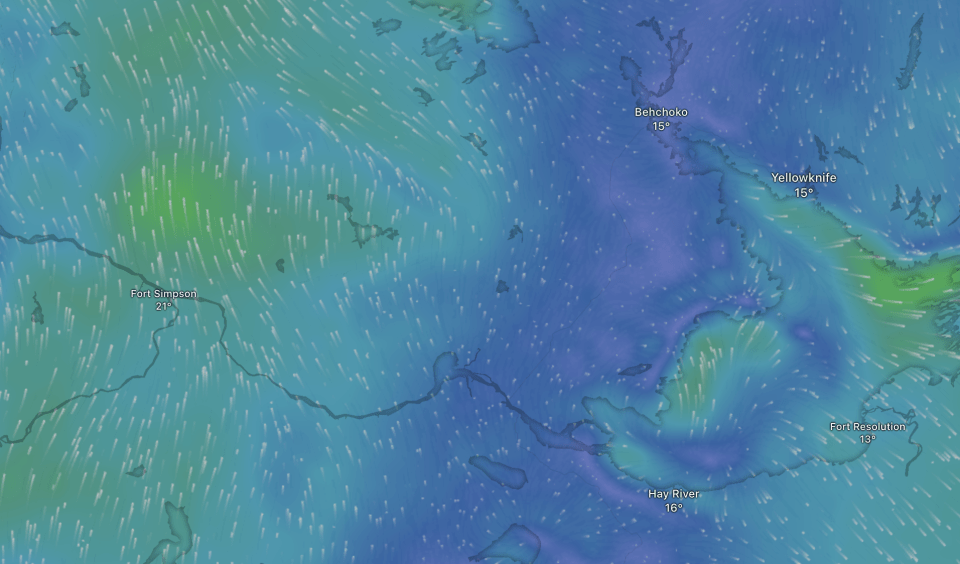
Environment Canada forecasts winds of no more than five kilometres an hour for most of the day in Whatì and Fort Providence, with highs of about 18C in those communities by late afternoon.
Winds from the south and southeast are expected to build in and around Jean Marie River this afternoon, picking up to about 15 km/h between 3pm and 9pm. Those winds shouldn’t push fire FS014 – which is northwest of Jean Marie River – toward the community.
6:30 – Good morning. There was a beautifully clear sky over Yellowknife when the dog and I went for an early inspection first thing. Here’s hoping for a good Thursday. We’ll take a look at the broader Thursday forecast for key areas shortly.