


Advertisement.
Whatì residents have been told they can go home on Saturday, while Fort Simpson is anxiously watching the progress of fire FS014.
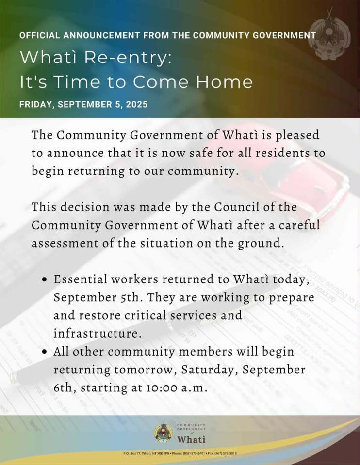
Whatì’s community government announced a re-entry plan on Friday that will see residents return from 10am on Saturday. Essential workers have already returned, the community stated.
“It is now safe for all residents to begin returning to our community. This decision was made by the Council of the Community Government of Whatì after a careful assessment of the situation on the ground,” Friday’s announcement read.
The community had been evacuated a week earlier over fire ZF048 to the southeast. Yellowknife’s evacuation centre will close on Sunday as a consequence, with the city saying it would work alongside the NWT government to help remaining evacuees from Fort Providence.
Advertisement.
Advertisement.
Meanwhile, fire FS014 was two kilometres from Highway 1 outside Fort Simpson as of Friday morning.
While the road remained open as of 4pm according to Drive NWT, NWT Fire said there was still a “high likelihood” the fire reaches it before the end of the day.
“The wildfire is not assessed to be a threat to Fort Simpson or the Fort Simpson airport at this time. The Liard River provides a strong buffer to fire growth to the Fort Simpson side of the river,” NWT Fire stated.
Highway 1 relies on a ferry across that river to reach Fort Simpson. If the road closes on the Liard River’s eastern shore, that cuts off the village from Yellowknife, Hay River and southern Canada, though the road west to Wrigley – where the highway ends – would remain available.
Advertisement.
Advertisement.
Mayor of Fort Simpson Les Wright told Cabin Radio the village is prepared for a road closure if one happens. “The Northern store is well stocked and we’re good till the next truck Tuesday,” he said, referring to the local grocery store.
However, a closure of Highway 1 would mean Jean Marie River can no longer plan to use the village as an evacuation centre.
Jean Marie River is on evacuation alert because of fire FS014’s southeastern flank, though that hasn’t moved closer to the community in a few days. Fort Liard or Fort Nelson could be alternative evacuation centres, Wright said.
Elsewhere, Highway 3 north of Fort Providence reopened at 10am and is expected to remain open until midnight. It was closed earlier on visibility grounds and will close again overnight.
Though officials say conditions remain too dangerous for residents of Fort Providence to return home after five days under an evacuation order, senior administrator Susan Christie said information about a re-entry plan was likely to be published over the weekend.
Live reporting by Ollie Williams
All times MT
18:26 – The highway situation is unchanged. At the time of writing, Highway 1 is still open. Check Drive NWT for the latest.
We’re closing down live coverage for the night. Stay safe and wishing Whatì residents a happy journey home on Saturday.
Advertisement.
Advertisement.
Live coverage will return if there are major developments over the weekend, otherwise news stories will appear in their regular format on our homepage.
18:14 – “Everyone is just crossing their fingers and praying and just hoping that someday, or some hour, we get some water from the sky,” said Dehcho Grand Chief Herb Norwegian of people in Fort Simpson.
He said he’s looking to do a water ceremony on Saturday afternoon.
“There’s traditional methods on how to deal with fire,” he told my colleague Claire McFarlane.
18:12 – Buses back to Whatì for evacuees will depart Yellowknife’s fieldhouse at 11am on Saturday.
18:07 – An update on the Fort Providence fire: NWT Fire says crews are continuing to mop up the ignition line from the edge of the fire guard in front of fire SS014.
“Water cannons and sprinklers at the edge of the community remain in place. Dozers are tight-lining the fire perimeter along Highway 3 up to 30 feet,” the wildfire agency stated this afternoon.
“Mulchers and structure protection teams successfully created access to the cabins along the north side of the Mackenzie River, east of the Deh Cho Bridge, to deploy sprinklers if required.”
Advertisement.
Advertisement.
18:03 – We asked Catherine Newsome, a spokesperson for Northwestel, about the risk to Fort Simpson’s connectivity from wildfire FS014.
Newsome said there’s currently no disruption to service. “The fire is near our infrastructure, but the good news is our infrastructure is buried there, and there’s been a considerable amount of firesmarting done – including sanding over in-ground electronics – and a lot of brushing of any vegetation,” she said.
“There’s been a lot of investment in that area, but we’re watching it closely, and we’ve got teams on standby if something goes on.”
17:10 – The City of Yellowknife has slightly revised its guidance on when facilities that doubled as an evacuation centre will reopen.
Initially, the city said the fieldhouse and multiplex would eventually reopen to the public “in the coming week.”
In an update, the city now says only the Northwestel field in the fieldhouse will remain temporarily closed. “All other amenities and programs within the fieldhouse and multiplex will reopen to the public on Monday,” the city added.
16:27 – NWT Fire says the Whatì fire could still grow to the east and crews working on containing it should be given room as people return home.
“When returning home, avoid the wildfire-affected areas as falling trees, continued heat on the ground and ash pits are real hazards,” the wildfire agency stated.
Advertisement.
Advertisement.
“There may be fire crews near the airstrip working on completing some mop-up tasks. Please give them the space they need to work.
“You may still see some fire activity and smoke in the distance or along the Tłı̨chǫ All-Season Road. The fire is not under control, but the areas which most threaten the community are contained.”
16:21 – Yellowknife’s evacuation centre will close at noon on Sunday, September 7, the city just announced, following on from Whati’s plan to bring people home on Saturday.
City Hall said it was working with the NWT government “to ensure remaining Fort Providence evacuees receive continued support.”
“The fieldhouse and multiplex will remain closed to the public as our staff work towards getting the facility back to regular working order. We will complete this work and re-open before the end of the coming week,” the city stated.
16:13 – It’s also worth noting that NWT Fire thinks there’s a good chance fire activity on FS014 could increase as we head into the evening.
On Saturday, crews expect a wind shift to the northwest that would push the fire away from Highway 1 and the Liard River. However, with communities on both sides of the fire, that of course means the fire might be expected to grow to the south and east, toward Jean Marie River.
16:09 – There’s a new update from NWT Fire on FS014. The key points are:
Advertisement.
Advertisement.
The fire hasn’t reached Highway 1 yet despite advancing slightly, but the wildfire agency thinks there’s still a “high likelihood” that happens today.
Crews and specialists are patrolling Highway 1 on the east side of the Liard River “and are prepared to use the highway as an anchor to suppress the wildfire and hold it to the east side of the highway,” NWT Fire stated.
“Structure protection efforts, including sprinkler setups, to the east of the Liard River are under way to prevent structure loss should fire approach the Liard River.”
Lastly, NWT Fire says the fibre line in the area is buried to protect against wildfire, despite concerns from community leaders and local emergency responders about losing connectivity.
(Though a buried cable is obviously much safer than one dangling above ground – as is the case in other parts of the territory – buried equipment has not always been immune from fire in the past. We’ve approached Northwestel for more detail about connectivity into and out of Fort Simpson, including any backup fibre options.)
15:49 – No change in the status of the NWT’s various highways. Highways 1 and 3 remain open at the time of writing. Remember, Highway 3 will close again at midnight until at least 8am on Saturday.
15:08 – We have short separate stories on Whati’s return home and Fort Simpson’s preparations where you can get the latest on both.
14:50 – Here’s the summary of Whatì’s re-entry plan, just published by community leadership:
Advertisement.
Advertisement.
14:48 – Whatì has just announced residents can come home on Saturday. More follows!
14:46 – This map from Firms, the Nasa satellite hotspot site, shows a satellite pass that happened just after 1pm today. The red squares are the latest hotspots seen by the satellite at that time.
Those hotspots suggest no major shift in FS014 so far today. That being said, we’re still quite early in the day and wildfires are often at their most active in the late afternoon to early evening.
14:38 – So far, Highway 1 appears to have remained open. We just got some fresh satellite hotspot info in, stand by for that.
13:11 – Highway 1 on the eastern side of the Liard River now has a flag on it on Drive NWT’s map warning it is expected to close in the near future with little or no notice.
13:09 – Łı́ı́dlı̨ı̨ Kų́ę́ First Nation Chief Kele Antoine reiterated just now that the village of Fort Simpson isn’t currently under threat from fire FS014.
“We’re preparing for possible road closures and possible communications disruptions as the fibre line runs along the highway.” Chief Antoine told my colleague Claire.
“We’re asking everybody to stay alert. Check on family and neighbours.”
Advertisement.
Advertisement.
While there is no immediate threat to the community, he suggests that people be prepared with an overnight bag packed and to take note of things like medication, wallets and identification in case they need to be packed quickly.
“We encourage people to stay calm, stay prepared and trust that information will be shared as soon as it becomes available,” said Antoine.
12:27 – RCMP have provided some information about the incident that caused Highway 3’s lengthy closure on Thursday. This is the first official word we’ve had about what occurred.
“On the morning of September 4, Fort Providence detachment received a report of a collision on Highway 3 north of the community. Officers attended to find two commercial vehicles and a passenger vehicle had been involved in a collision, however no injuries were reported,” a police spokesperson told us by email just now.
“Visibility was near-zero, creating extremely dangerous conditions. This investigation remains ongoing with no charges laid at this time.”
12:06 – Mayor of Fort Simpson Les Wright has been speaking with my colleague Claire McFarlane about fire FS014.
Wright reiterated the possibility of losing fibre internet, phone and road access on Friday as wildfire FS014 threatens Highway 1. If the village loses internet, Starlink access will be available at the village office, recreation centre and library.
“Fort Simpson itself is not under threat right now from the fire,” said the mayor. He said that while the road closure may create some challenges, the community is prepared.
Advertisement.
Advertisement.
“We deal with road closures all the time, so it may be closed for an hour, could be closed for a day,” said Wright. “The Northern store is well stocked and we’re good till the next truck Tuesday.”
He said if an evacuation order is called for Jean Marie River – which is currently on evacuation alert – the community wouldn’t be able to evacuate to Fort Simpson due to the expected road closure.
Instead, the mayor said they are looking for options in Fort Liard or Fort Nelson to the south.
11:48 – NWT Fire has received criticism (which it rejects) from some evacuees who feel as though fires affecting communities could have been more aggressively fought at an earlier stage.
The wildfire agency, in its update on FS014 just now, appears to try to pre-empt more of the same criticism by outlining work done on this fire.
“Visibility remains a major challenge for action from the air – both from helicopters and airtankers – which have been smoked in for several days and prevented from access much of the west flank of this wildfire,” the update states.
“This wildfire has been fought since detection on June 27 – with direct action to contain the fire having escaped containment efforts, driven by severe drought and extreme weather events.”
11:44 – From Fort Simpson’s fire and ambulance service:
“Our team are maintaining emergency services within the Village, as well as staying in constant contact with other emergency response organizations in Łı́ı́dlı̨ı̨ Kų́ę́.
“If communications drop out and you can’t reach us or 9-1-1 via phone, please go directly to the Health Centre for medical care, or report other emergencies at the Fire Hall.”
11:36 – Łı́ı́dlı̨ı̨ Kų́ę́ First Nation Chief Kele Antoine writes:
“The forest fire is nearing Highway 1 and closures are expected today. These closures could last for a day or so. This may also affect fibre internet and telephone services.
“Fort Simpson is not under direct threat at this time. In the event of communication loss, free access to satellite internet (Starlink) will be available at:
• Rec Center
• Village Office
• Library / Fire Hall
“Please plan ahead for possible road closures and check in on family and neighbours. We’ll continue to share updates as new information becomes available.”
11:29 – Here is the latest from NWT Fire – and this is a significant update, I have placed the key parts in bold – on FS014 between Fort Simpson and Jean Marie River:
“The wildfire may reach Highway 1 between km 452 and 454 by 2pm today based on current and projected weather and fire behaviour. The wildfire is not assessed to be a threat to Fort Simpson or the Fort Simpson airport at this time. The Liard River provides a strong buffer to fire growth to the Fort Simpson side of the river.
Advertisement.
Advertisement.
“There is a high likelihood Highway 1 could be closed during the afternoon today due to fire activity. Highways staff are monitoring the area closely and are in close contact with regional wildfire management staff.
“Unfortunately, due to visibility issues, which cause safety concerns for both air and ground crews, we have been unable to hit the fire with water or fire retardant on the side of the fire closest to the highway.
“Significant suppression has been done on the southwest end of the fire closest to Jean Marie River in the last few days to help reduce the likelihood of growth towards Jean Marie River.”
11:18 – The Department of Infrastructure expects Highway 3 to now remain open until midnight tonight.
11:03 – Drive NWT now indicates Highway 3 is fully open, but proceed with caution.
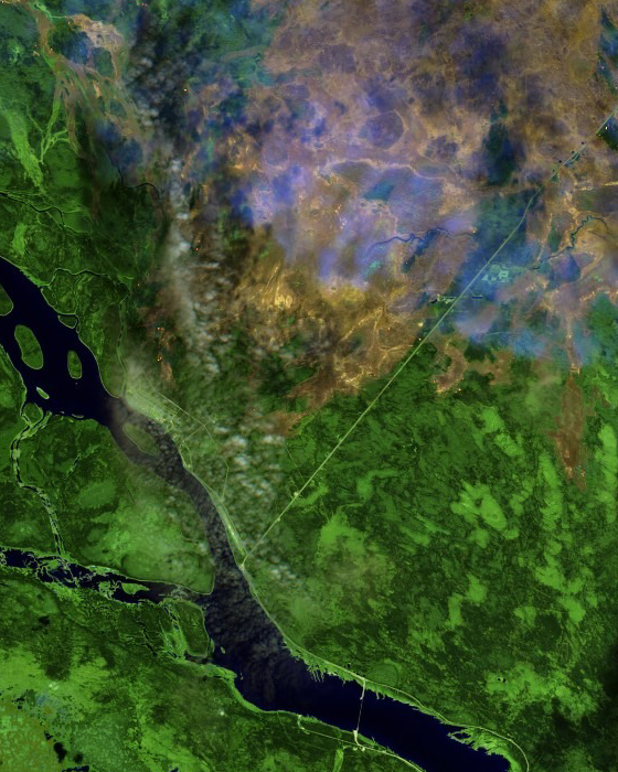
11:01 – Earlier, we had Sentinel-2 satellite imagery of Fort Providence on Thursday (see the 7:30am update). Now, here’s the same thing for Whatì.
The below images are Thursday shots of fire ZF048 south of Whatì. They show the false-colour version, which makes it easier to pick out hotspots and burn area, and the true-colour image.


Advertisement.
Advertisement.
10:32 – Hay River’s Soaring Eagle Friendship Centre is inviting evacuees to “check out all the donations,” ranging from clothes to shoes and toys. Details here. The centre’s open till 5pm today according to its published hours.
10:20 – From my colleague Claire McFarlane, who’s covering fire FS014:
Lynn Canney, a B&B owner in Fort Simpson, said she can see through the smoke across the river today. She said that on Wednesday, the smoke was the thickest she’d ever seen in the area.
She said she isn’t worried about the fire being on Fort Simpson’s doorstep since it would have to first cross the Liard River, though she’s ready to evacuate nonetheless.
“Noting that in Fort Providence, they had, I think, less than 24 hours between an alert and the order to go, we’ve gotten ourselves ready,” she said. “We have an RV that we purchased after the flood, just in case we have to evacuate at any point in the future, so it’s packed and ready.”
She said she feels “hints of 2023.”
“What’s getting me through today is knowing that the nights are longer, they’re cooler. That fire is going to start losing speed.”
10:11 – I’ve seen a couple of reports that pilot vehicles have begun escorting traffic along Highway 3, and the Fort Providence webcam does show some movement. No official update yet.
Advertisement.
Advertisement.
9:37 – I’m aware that residents of Fort Simpson are keeping a very close eye on FS014 and its proximity to the highway today. My colleague Claire McFarlane and I are similarly keeping tabs on it and we’ll bring you updates on that fire as we get them. See the 6:52am update below as well.
Also, I’m told the GNWT network is back.
8:57 – Adding to the mix, I have now heard from multiple people that the GNWT’s internal network is down across many (if not all) parts of the territory. I don’t have anything official on the scope of that outage but it’s preventing at least some territorial government staff from accessing email and internet.
8:41 – Tiny addition re Highway 3: the GNWT says staff are patrolling all day and will reopen it as soon as visibility and conditions allow.
8:22 – The GNWT says Highway 3 will remain closed because of poor visibility. There’s no timeline for when it will reopen today.
8:06 – No immediate update on Highway 3. The webcam at Fort Providence, which updates hourly, just refreshed and still shows traffic lined up.
8:04 – The smoke forecast suggests Fort Simpson could struggle again today with plenty of smoke being generated by FS014 and moved in the village’s direction.
Yellowknife and Hay River ought to have reasonably clear air by recent standards, according to the FireSmoke forecast and Environment Canada’s air quality forecasts. Norman Wells might see a lot of smoke today, though.
Advertisement.
Advertisement.
You can get the NWT’s current air quality map here.
7:30 – These Sentinel-2 satellite images show Fort Providence and fire SS014 on Thursday. Use the slider to move between the false-colour version on the left, which can see beneath the smoke to an extent and depicts burn area and hotspots, and the true-colour version on the right.
Fort Providence is shown to the middle left of the picture. You can see the highway bridge over the Mackenzie River at the bottom right.

7:20 – Susan Christie, Fort Providence’s senior administrator, issued an update to residents last night.
“The ignition operation that was conducted on Tuesday continues to hold and provide protection for the community. Dozers and fire crews continue to secure the fire’s edge nearest the community. Mulchers are working to gain access to cabins on the north side of the Mackenzie River, southeast of the community, so structure protection specialists can set up sprinklers as needed,” Christie wrote.
“Re-entry discussions continue to happen with the LEMO, ECC, and MACA. Once ECC determines it is safe enough for the structural protection to come down, fire crews will begin demobbing the firehoses and sprinklers that are set up around the community. Once that has been complete, we will be close to letting you come home! Please look for information to be posted on the re-entry plan over the weekend.”
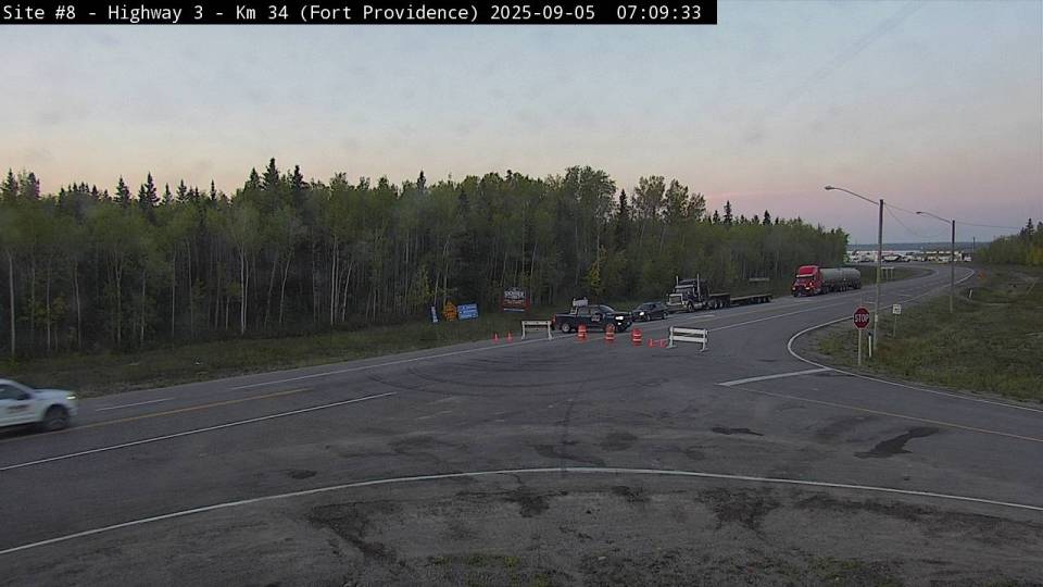
7:09 – Here’s the scene outside Fort Providence, where vehicles are lining up in the expectation that Highway 3 might reopen soon.
Advertisement.
Advertisement.
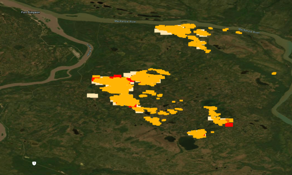
6:52 – This morning we’ll also be keeping an eye on FS014, which satellite hotspot detection suggests is now quite close to Highway 1 near Fort Simpson. Here are two example maps. The first is from Firms, the Nasa-backed hotspot tracking website:
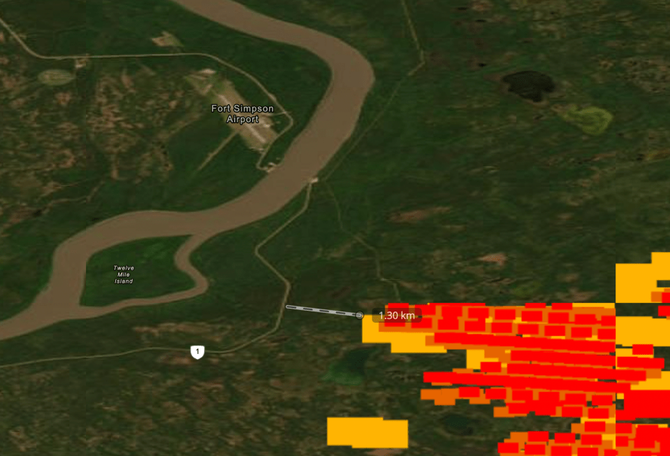
Keep in mind that fires don’t move in big, rectangular blobs, so the area indicated by Firms (the oranges and reds are hotspots from the past 12 hours) isn’t necessarily the precise area in which the fire is burning. The figure of 1.3 km between the fire and road may be more in real life. Highway 1 remains open according to Drive NWT.
Here’s a second version showing essentially the same data. You can get this from the GNWT’s own wildfire map by selecting the layers option in the top right and choosing satellite hotspots.
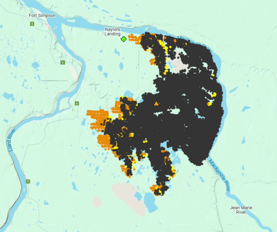
In this map, the orange dots are satellite hotspots detected in the past 12 hours. Yellow dots are 12 to 24 hours old and black dots are older hotspots, doubling as a useful approximation of burn area.
This version shows the general progress of the fire westward over the past day. From a Jean Marie River perspective, good news. From a Highway 1 and ferry landing perspective, a little trickier.
6:36 – Good morning! I hope you’re doing OK over there. The main news first thing this morning: remember Highway 3 is closed. We expect it to reopen at around 8am but that could change.