


Advertisement.
The NWT government’s latest analysis of what’s happening to the territory’s water suggests the recent cold weather will continue – but conditions might start to chip away at the region’s years-long drought.
Above-normal snowpack in the river basins that feed the NWT’s major waterways is the most encouraging signal in nearly four years that the territory’s drought could begin to ease.
But water levels on Great Slave Lake, the Mackenzie River and other key water bodies remain well below average – and the NWT government’s latest water monitoring bulletin stops short of predicting a recovery.
The March bulletin, published last week, also warns northerners this winter’s cold weather will stay a while longer.
Advertisement.
Advertisement.
“Cooler-than-average temperatures are expected to persist into April, before transitioning back to near-normal conditions in May,” the bulletin states.
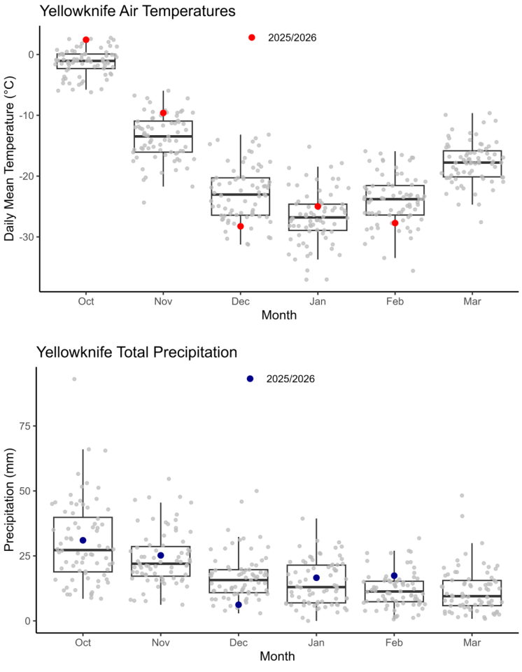
February temperatures were below average in Yellowknife and Norman Wells, the bulletin reports, while conditions were generally average elsewhere in the territory. Precipitation was average to above average, with Fort Smith, Yellowknife and Norman Wells all recording above-average precipitation for the month.
That continues a pattern from earlier in the winter. December was unusually cold across the NWT and snowfall has been consistent in many communities.
For Yellowknife, the combination of cold and snow has made for a distinctly wintry season after a warm fall.
Advertisement.
Advertisement.
Where the snow falls matters
While NWT snowfall is important, the territory’s biggest rivers and Great Slave Lake are fed by water that originates much farther south, in northern Alberta and British Columbia.
That’s where the picture is most encouraging.
Snow water equivalent – the amount of water contained in the snowpack – is above normal across much of the western and southern Mackenzie River basin as of March 1, according to data compiled by the territorial government.
The headwaters of the Slave, Liard and Hay rivers in northern Alberta and BC have particularly high snowpack.
The February bulletin had already flagged record-high cumulative precipitation in the Peace River headwaters. The March data suggests the trend has continued.
“Water levels on the Slave River, Great Slave Lake and the Mackenzie River this coming spring/summer will be impacted by snowpack volumes and spring rainfall amounts in northern Alberta and British Columbia,” the bulletin states.
The NWT government says it is working with neighbouring provinces and territories to compile snow survey results across the Mackenzie River basin. Those results will be published in a spring water level outlook.
Don’t call it a recovery yet
Despite the more promising snowpack data, the drought that began in the summer of 2022 has not let up.
Advertisement.
Advertisement.
Water levels and flow rates remain very low across most of the NWT. Great Slave Lake is well below average and lower than the level recorded at this time last year, which was also below average. The Slave, Hay, Liard and Mackenzie rivers are all below or well below average for this time of year.
Great Bear Lake remains at its lowest water level on record for this time of year, similar to the level recorded last year.
The Peel River – which had been an outlier throughout the drought, running higher than other NWT rivers for much of the past few years – is average for this time of year.
The spring melt will be a key test of whether this winter’s snowpack translates into higher water for the NWT.
A cooler-than-average spring could actually help. A gradual melt tends to allow more water to soak into the ground and flow steadily into rivers and lakes, rather than evaporating or running off quickly in a sudden warm spell. (A gradual melt also helps lower the risk of a spring flood, which always has to be kept in mind when talking about a high snowpack.)
But NWT hydrologists have repeatedly cautioned that the territory needs sustained, above-average precipitation – not just one good winter – to meaningfully recover from a drought of this severity. The NWT has seen glimmers of hope before that didn’t pan out.
The territorial government publishes water monitoring bulletins monthly. Its spring water level outlook is expected in the coming weeks.