


The City of Yellowknife is mapping out where to put the next generation of housing for a community sorely in need of more homes.
On Monday, city councillors will study maps that show where in Yellowknife municipal staff think future housing developments should go. The key word? Infill.
For years, the city’s planning philosophy has been to fill in the gaps rather than expand.
Grace Lake, at the southern end of Yellowknife, was the last major residential expansion – put into motion about eight years ago. Since then, the city has tried to focus on encouraging development that won’t require adding services like new water lines or trucked delivery, new transit routes, new demands on garbage and snow-clearing teams and so on. All of those would cost money (and might contribute to a tax increase).
Advertisement.
Advertisement.
That means building where all those services already exist.
Rebecca Alty, the city’s mayor, said in a Friday Facebook post that the city wants “minimal added costs” as a consequence of new housing.
“With infill, we have more taxpayers (revenue) but with minimal costs,” Alty wrote. “This benefits all residents versus adding a new subdivision.”
So where are the gaps?
Advertisement.
Advertisement.
City staff will use Monday’s meeting to walk councillors through some target areas. (Here is the agenda with supporting documentation for that meeting, which you can watch live or on demand.)
Some are easier to develop than others, for example because of the surrounding infrastructure or because they require minimal paperwork to turn them into land that might be attractive for developers.
Others would need a community plan amendment, which likely means a longer bureaucratic process before the land becomes available.
Here are the areas of Yellowknife the city will identify as targets at Monday’s meeting.
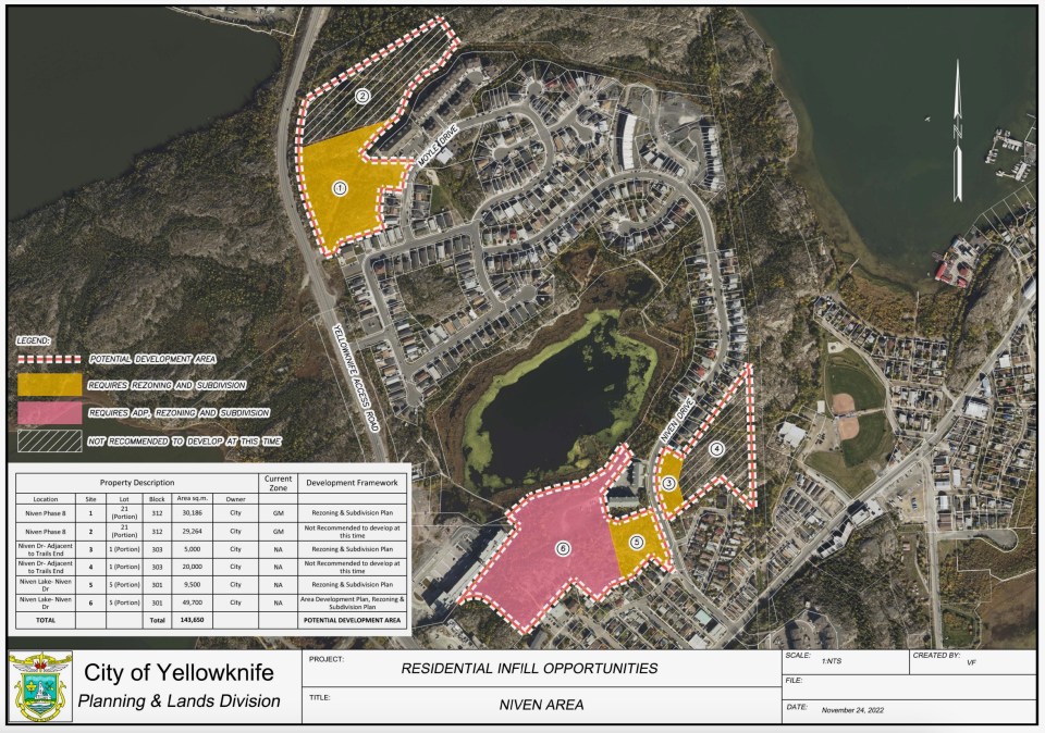
Niven Lake
The city suggests developing around half of the land between Moyle Drive and the main road running into Yellowknife from the highway.
On the other side of Niven Lake, there is open space next to large Northview apartment buildings at 97 Niven Drive that the city also wants to target.
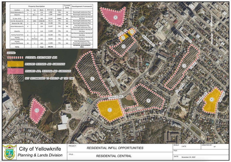
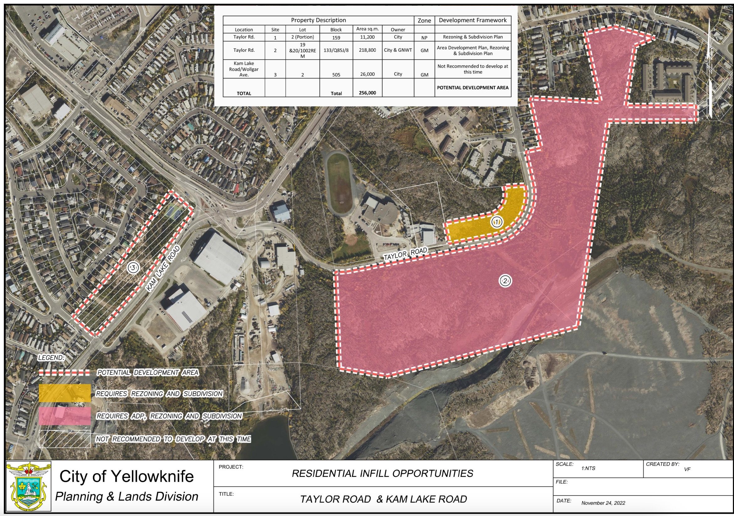
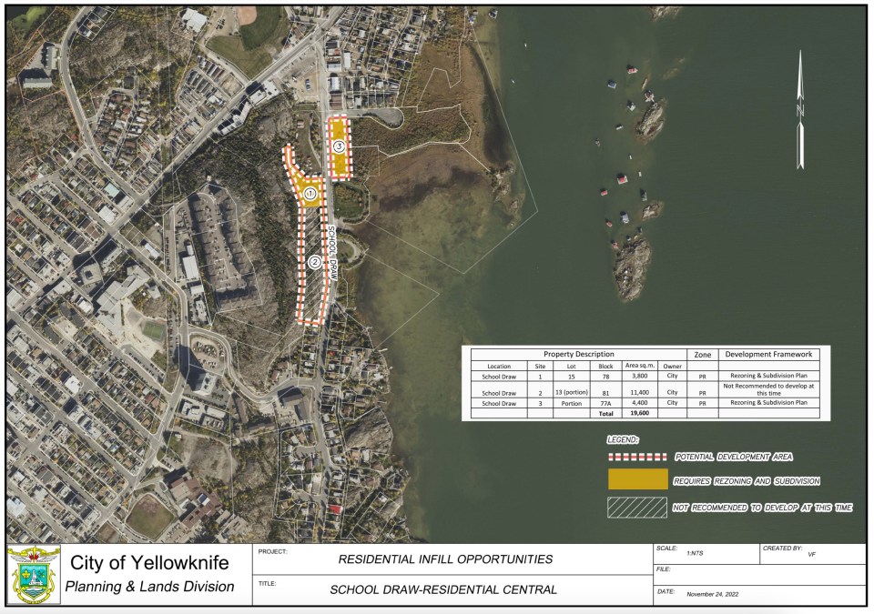
(On the maps, yellow means an area would need rezoning and subdivision. Pink means it would need those things plus an area development plan. The areas that have a pink border but aren’t coloured are “not recommended to develop at this time.”)
Central Yellowknife
There are three patches of land off Gitzel St and Matonabee St that the city has earmarked.
Advertisement.
Advertisement.
A large section of vacant land across Reservoir Road from the Tommy Forrest ball diamond make the list, as does land north of Northlands next to Frame Lake.
The rocky area between Burwash Drive and Con Road is also highlighted.
Taylor Road
With remediation of the neighbouring Con Mine nearing completion, the city has its eye on filling in much of the land around the road that runs past École Allain St-Cyr and William McDonald Middle School.
There are stretches on both sides of Taylor Road marked for possible development.
School Draw Avenue
A stretch of School Draw Avenue between Lundquist Road and Rotary Park is highlighted on city maps to be presented on Monday.
Also singled out is a stretch of land on the other side of the street, next to the Bartam Court development that is already under way.
What happens next?
City councillors will review these suggestions at a Monday lunchtime meeting. Councillors could suggest amendments, such as taking areas off the list or adding others – or taking a different approach entirely.
Once council decides where the city’s housing focus should be, there’ll be a formal vote on January 23 to instruct staff to get on with the work.
Advertisement.
Advertisement.
Alty said various legislative and administrative steps then follow (there’ll probably need to be some rezoning and the creation of some planning tools called area development plans). Each of those steps will come with some form of public discussion and a council vote, the mayor stated.
“The recommended land parcels all require, at minimum, a rezoning and subdivision. It’s still too early to say when those will come forward to council for public input and a vote,” she wrote.
Residents who want to give council their opinions or suggestions can either write to council or ask to be added to the list of speakers by emailing the city clerk.