

Advertisement.
Extraordinarily hot weather is diverting the attention of Northwest Territories authorities from possible floods to the prospect of wildfires.
So far, breakup season is proceeding quickly and quietly. In Hay River, for example, no action has been needed after a precautionary evacuation notice last week and daily updates have been scaled back.
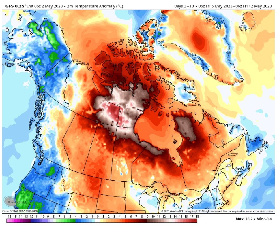
Yet even as attention remains on the possibility of flooding, places like Hay River and Fort Smith are now contending with daily highs of more than 20C throughout much of this week – temperatures that are setting one-day records.
Advertisement.
Advertisement.
For instance, Monday was Fort Smith’s warmest May 1 since records began, reaching 25.5C.
“The season begins,” the NWT Department of Environment and Climate Change’s Facebook wildfire updates page declared on Monday.
The department will hold a full season briefing for reporters on Thursday, setting out its outlook for the opening months of the summer.
There were no active wildfires in the territory as of Monday, but ECC warned that “much more extremely warm and dry weather is expected in the south NWT in the coming week.”
Advertisement.
Advertisement.
“The ground will dry out fast,” the department stated. “Don’t let the date fool you – it’s time to get vigilant and do everything you can to prevent wildfires.”
Hay River, Fort Smith and Fort Simpson are all expected to reach 25C this week. Yellowknife is forecast to hit 20C on Friday and Saturday.
Last year’s NWT wildfire season was extraordinarily prolonged.
Fire crews had to contend with unusually wintry equipment issues, like sprinklers freezing, as the season dragged into the back half of October.
The GNWT’s wildfire activity webpage stopped reporting on the season on October 25, 2022.
At that point, there were still 30 active fires and 686,595 hectares had been burned – above average for the territory but still well below the millions of hectares burned in 2014, the most severe summer on record.