


Advertisement.
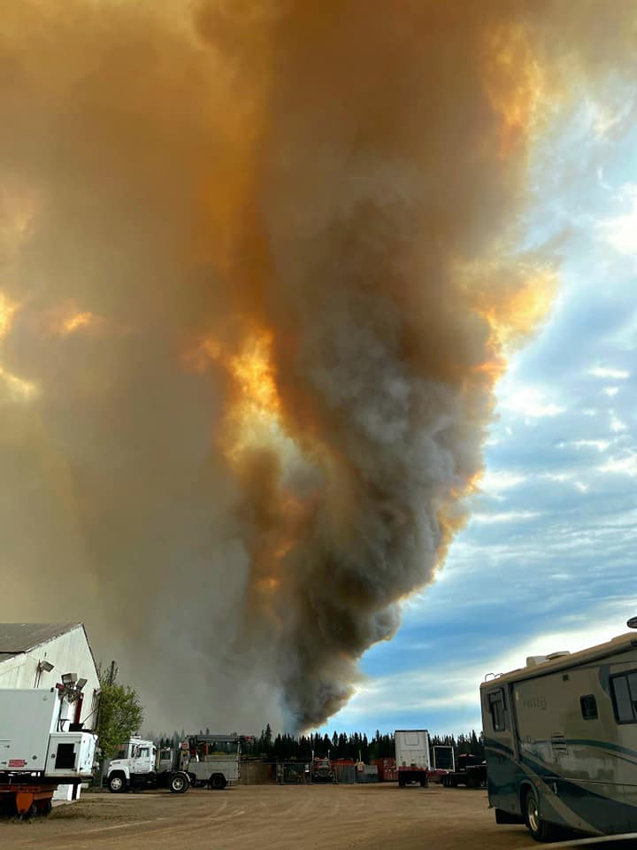
Overnight rain and favourable winds helped efforts to tackle a wildfire at the edge of the Kátł’odeeche First Nation and near Hay River, but the fire remained out of control on Tuesday.
In an 11:30am update, the Town of Hay River said the likelihood of shifting winds later in the day was also expected to produce “very poor air quality” and the overall risk to the town remained high.
“Staff are actively working on a plan for residents to return safely if we receive positive news in the next few days,” the town stated, while urging people to stay away. A more detailed update on the fire itself, from the NWT’s wildfire agency, is expected shortly.
Advertisement.
Advertisement.
Winds blew from the northwest in the early hours of Tuesday, conditions that help to keep the fire – which is to the east – away from the communities. The night brought a temperature drop to 4C and scattered showers.
While those showers alone won’t be enough, overnight conditions were far more helpful than the warmer temperatures, dry surfaces and occasional easterly winds that made the fire so dangerous on Sunday and Monday, driving it into the First Nation and almost across the river to the town.
The Town of Hay River said in an earlier update that teams in Hay River had successfully handled small fires as embers landed on the far side of the river from the main wildfire, with no damage to any buildings or property.
Damage on the Kátł’odeeche First Nation side of the river is known to be more substantial, but authorities have so far not been able to confirm its extent.
Advertisement.
Advertisement.
“Emergency crews have to complete the assessment of Kátł’odeeche once the Nation is safe but, at this time, we are still fighting fire,” the First Nation stated on Tuesday morning.
The first clear satellite imagery of the fire, a Sentinel-2 satellite pass on early Monday afternoon, shows a significant burn area to the east of the Hay River, bordering the Kátł’odeeche First Nation.
Data from the Canadian Interagency Forest Fire Centre and Natural Resources Canada puts the fire at some 800 to 900 hectares in area burned so far.
While the satellite images’ resolution is not detailed enough to pick out with certainty the fate of individual buildings, the NWT government estimated on Monday morning that around 15 KFN buildings had been affected by the fire at the time.
Video posted to Facebook shortly before 9pm on Monday appeared to show that the First Nation’s Dene Cultural Institute had fallen victim to the fire but a next-door treatment centre remained standing. The First Nation earlier reported that “all history and archives” had been rescued from the institute as the community was being evacuated.
Around 4,000 people in the two riverside communities were told to leave their homes on Sunday as a wildfire named SS005 rapidly developed in the vicinity. Strong, swirling winds have made the task of battling the fire a complicated one for the six crews now assigned to it, with more on the way.
On Monday evening in Hay River – now almost deserted except for fire crews and police watching over the community – workers dampened the riverbank in the hope of preventing the fire taking hold on the river’s west bank should the wind change.
Rain in the region has now dried up and the strong northwest wind that blew overnight was forecast to drop by Tuesday afternoon.
Advertisement.
Advertisement.
The remainder of the week is expected to be sunny. Only very light winds are forecast for the rest of Tuesday.
The NWT government’s wildfire agency has said any northwest wind (meaning wind blowing from the northwest to the southeast) will push the fire away from the communities. The fire began to the east of the First Nation, and the gravest danger for KFN and Hay River is when the wind blows from the east, pushing the fire toward them.
However, strong wind in any direction “may still increase fire size and tax firefighting efforts,” the GNWT stated on Monday.
Fire crews have had to fall back multiple times because of the sheer volume of smoke emitted by the fire, but air tankers and helicopters were back fighting the fire from the air as of late Monday afternoon.
The Town of Hay River has repeatedly warned residents that returning is unsafe and out of the question. Highway 2 into Hay River has been closed at its intersection with Highway 5, meaning residents of Fort Smith and Fort Resolution can still travel to and from their communities but the road north of the intersection into Hay River is blocked.
Hay River’s health centre closed on Monday and its jail’s inmates have been moved to Yellowknife.
While thousands of residents have headed for Yellowknife’s evacuation centre or other communities, a small number of people are known to have stayed behind.
More: At the multiplex, again, Hay River and KFN evacuees await news
Advertisement.
Advertisement.
“The risks are just so high with the changing wind conditions,” said town senior administrator Glenn Smith on Monday as buses tried to pick up anyone remaining.
“The situation can change very quickly and it’s not safe.”
Anyone still in need of transportation is urged to contact the town. RCMP are “actively monitoring” the community in the absence of most residents, the town stated.