


Advertisement.
The Hamlet of Fort McPherson has declared a state of emergency as water from the Peel River pours into low-lying areas of the community.
Much of Fort McPherson sits on slightly elevated ground but camps outside the community and some homes on the hamlet’s periphery have reported flooding over the past day.
At 7pm on Tuesday, the hamlet confirmed a state of emergency was in place, in part because of concern that it may shortly lose access to its source of trucked water, a lake along the highway north of the community.
Advertisement.
Advertisement.
Fort McPherson’s airport has also been cut off from the hamlet itself. Residents have been asked to conserve water, with the school, local government offices and youth centre among buildings shut down to try to cut down on water use.
Flood watch in Fort McPherson and other parts of the Beaufort Delta comes as southern areas of the NWT battle wildfires, leaving the territory’s emergency responders facing twin calamities.
States of emergency hand communities slightly more power to act in serious situations. They’re declared at local, not territorial level, and don’t necessarily mean an evacuation or similar action is imminent.
Warm temperatures on Monday contributed to snowmelt and rising water levels in and around Fort McPherson.
Advertisement.
Advertisement.
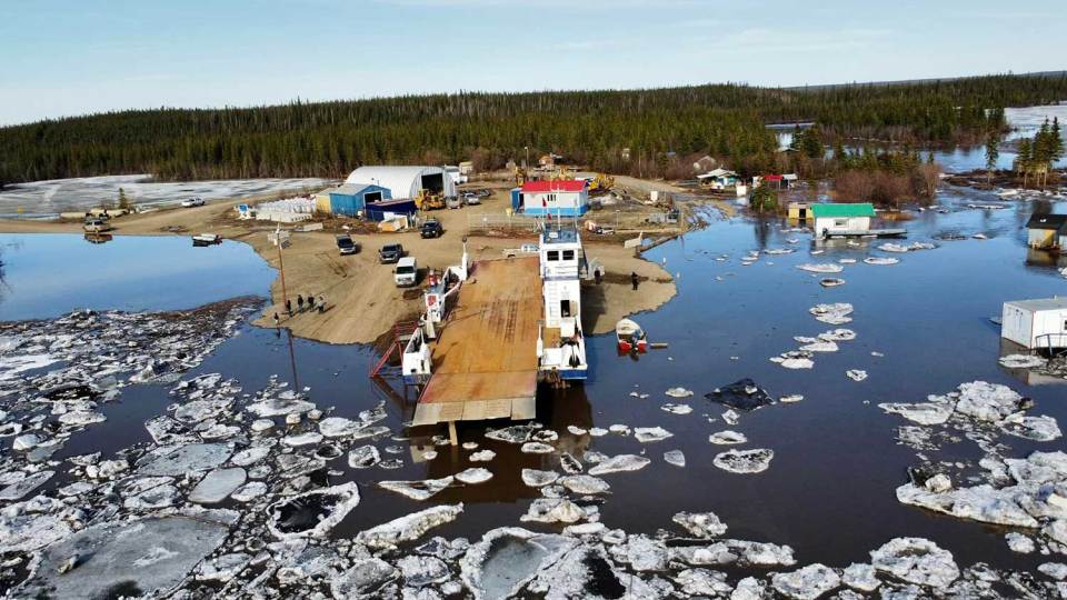
Video footage from Dean Charlie shows high water at the ferry camp south of Fort McPherson on Monday.
Richard Nerysoo, Fort McPherson’s former mayor and a former NWT premier, told Cabin Radio community members had to help residents leave the ferry camp, south of Fort McPherson, on Tuesday morning. He said the river had continued to rise since.
Footage shared online showed water from Mosquito Creek, just outside the community, overflowing onto the road.
Nerysoo said camps along the Peel have already been flooded out and he worries for people living on the land along the Peel and in the Mackenzie Delta, who can’t easily escape to higher ground.
Premier Caroline Cochrane, who arrived in Inuvik on Tuesday for a meeting with the Yukon and Nunavut premiers on Wednesday, said on Twitter: “I want to express my sincere sympathy to everyone impacted. I am receiving regular updates on the situation and I want residents to know that the territory is behind you in your time of need.”
He said Fort McPherson has already been struggling due to the recent loss of a community member.
“Even in the midst of a loss of an individual in our community – and we’re confronted by the challenge of flooding around our community, in our area – we’re still not going to lose sight of our relationship with each other, and our need to support and love one another in this exercise,” said Nerysoo.
Advertisement.
Advertisement.
Nerysoo said he hasn’t seen this kind of flooding in the area since the 1960s. He said the water is coming up onto roads in the community and has surrounded some homes.
He said the road to the ferry camp was dry enough to drive on Monday night but, by Tuesday, was covered with water that had risen by more than a metre overnight.
Ryan Connon, a hydrological modeller for the NWT government, said all of the gauges on the Peel River had been taken out by ice on the river.
Connon believes a monitoring camera near the community was also taken out by the ice as staff are no longer receiving pictures.
As a result, there is no real-time, up-to-date information about water levels on the Peel River.
In the last photos received from the camera, ice on the river was shown to be very thick, in contrast to melting ice on the Mackenzie River.
Cooler temperatures on Tuesday will probably hold the ice where it is already jammed, said Connon. Warmer temperatures expected on Wednesday will likely deliver more snowmelt water to the river.
Advertisement.
Advertisement.
Connon said he expects to receive satellite imagery of the river on Tuesday night or Wednesday morning, which will show where the ice jams are.
“There is still high potential for flooding along the Peel River over the next couple of days as snowmelt progresses, until ice clears out of the Peel River,” said Connon. Water levels are going to continue to rise rapidly, he said, and people should exercise extreme caution around flood waters and not cross any flooded areas.
“Even if there are areas that are flooded that usually aren’t, remember that water can move very fast,” said Connon. “The water is very powerful at this time of year.”
Nerysoo urged the community to stay vigilant and look out for children and Elders.
“We’ve just got to be vigilant and supportive wherever we can, and lend a hand where it’s necessary, and that’ll take us through this,” he said.
In Fort Good Hope, where the potential for flooding had also been a concern, Connon said water levels have begun to recede since Monday night.
A large ice jam had been occupying the Mackenzie River between Norman Wells and Fort Good Hope. Connon said most jammed ice has now moved past the town, which had “greatly diminished any flood risk.”
Warm temperatures and sunny weather this past weekend had melted the ice downstream, he said, leaving it unable to jam and hold back ice arriving from further upstream.
In Aklavik, there is no immediate risk but Connon said residents should prepare for high water levels in the days to come. A gauge near the community shows water levels slowly rising under the ice.
“High water in Aklavik will depend on how ice clears through the Mackenzie Delta, and which channels ice goes through, and which channels open up first,” said Connon.