

Advertisement.
Hay River is hosting two public meetings this week to discuss updating its flood hazard maps in its zoning and building bylaw and community plan.
The town’s existing flood hazard maps – which help guide safe community planning – were developed in the early 1980s, but 2022’s historic flood indicated an update was needed.
Hay River’s senior administrative officer, Glenn Smith, said the work began with mapping 2022’s flooding alongside years of historical data and other technical considerations raised by hydrologists and environmentalists.
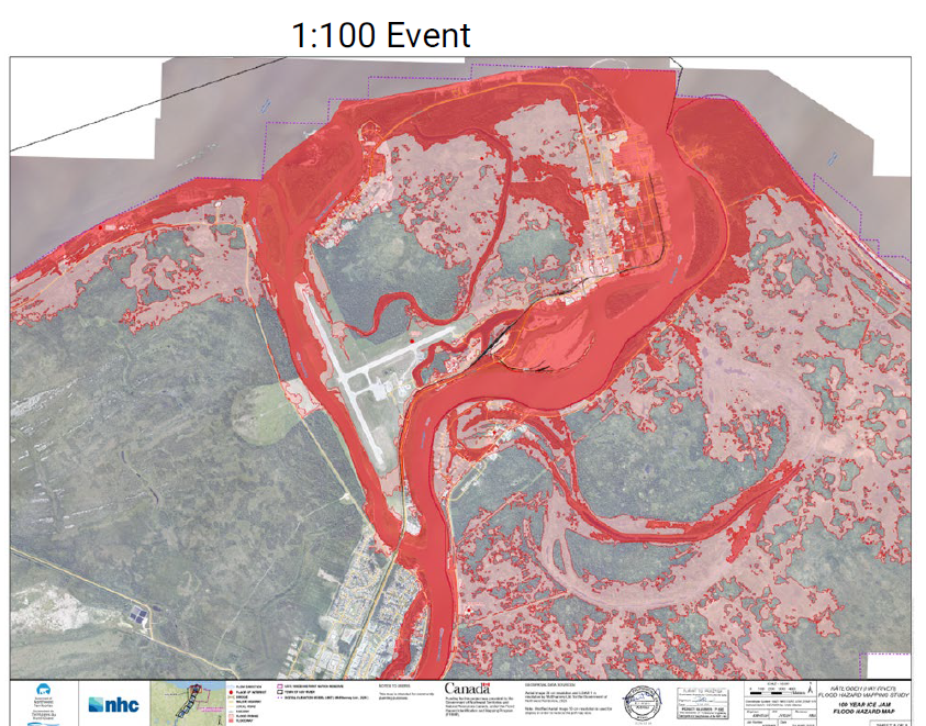
The map the town has used for the past few decades is a 100-year ice jam flood hazard map – that is, the map shows a severity of flooding projected to occur once a century.
Advertisement.
Advertisement.
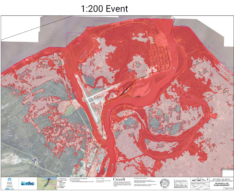
New maps created by Northwest Hydraulic Consultants give both 100-year and 200-year flood probabilities. The 200-year map shows the potential for greater flooding impact, but at a lower chance of happening – roughly once every two hundred years.
Hay River’s town council must now decide which map to incorporate into its development standards, or if there is another option not yet presented to consider.
The practical implications of the new maps are an effect on how people can build, and potentially on their existing property’s compliance with local laws.
For example, Smith said, new standards that will follow the adoption of a new map could require building elevations of a certain height, a non-permeable foundation, or not having a basement.
Advertisement.
Advertisement.
Smith doesn’t yet know if existing structures would be grandfathered in or if they would be required to undertake mitigation measures.
Council will also need to consider the GNWT’s agreement with the federal government’s Disaster Financial Assistance Arrangements program, which provides financial support to the territorial government during large-scale natural disasters.
“If they come back and say, essentially, you have to be within a 200-flood-year zone to be insured by this program, then some of the consequences are that properties might not be within that allowance,” Smith said.
“There’s very much a consideration of the impact of current versus safe and effective construction for future generations, and consideration of what seems to be more likely reoccurrence of major flood events.”
Hay River is hoping to adopt a new flood hazard map by the end of the calendar year, with the understanding that the maps will need to evolve as the climate changes and as other government bodies introduce new guidelines and legislation.
The first meeting for public feedback is scheduled for Tuesday evening at 6pm in person at the recreation centre community hall. The second meeting, a virtual one, will take place on Friday at noon. For access to the online meeting link, email consultants Stantec.
The town is also meeting with local Indigenous governments and the business community to discuss the flood hazard map options.
Ollie Williams contributed reporting.
Correction: October 11, 2025 – 16:15 MT. An initial version of this story attributed the new flood maps to Stantec. They were in fact created by Northwest Hydraulic Consultants.